The birds lay a single egg on the cliff ledges and have to protect the chick from Arctic foxes and glaucous gulls. The cliffs are dark rock with spires and crevices, patches of snow and patches of grass, and all of it stained with guano. Waves were crashing against the base of the cliff. The birds were perched all over the cliff, flying on and off the perches, floating on the water and diving. Their water landings often look chaotic. I took almost a zillion pix. We did see two foxes, their coats turning from white to blue-black, early on the cliff cruise. We also saw a bunch of the predatory gulls.

Bird cliffs - all those dots in the sky are birds. I'll put some videos on Facebook.

One guillemot...

More guillemots...

Many, many guillemots...

Guillemots on and under the water.

Foxes prey on the chicks.
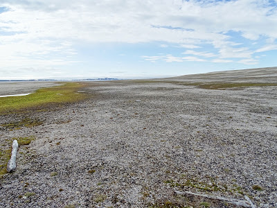
After lunch, the wind was gone, the sun was out and the water turned flat quite quickly. We landed on a stony beach at Torrelnessett, on the eastern side of Hinlopen Strait on Nordaustlandet. It is a long and wide beach with several well-defined terraces rising away from the ocean. The area is desert-like with scant plant-life, miniscule and infrequently distributed on the gravel. The areas around a very old whale skull and a piece of an old antler have more plants, fertilized by the organic matter. The terracing is attributed to isostatic equilibrium.
Simply stated, that means that when the glaciers covered the north with a kilometer or more of ice, the continental crust was pushed down into the earth’s semi-soft mantle by the weight of the ice. When the ice melted, the crust rebounded and gradually rose out of the mantle, in fact, it’s still rising. The upper most terrace was formed at sea level early in the process, but now is perhaps a hundred feet above sea level. Intermediate terraces formed as the land slowly rose.
The big excitement here was group of walruses, about three dozen, all males according to the guides. There were in a big scrum with occasional stirring around. One big old guy sat up for a look at us. One had a broken tusk. Some had gapped tusks and some misaligned tusks. There’s plenty of work here for an enterprising orthodontist.

Mid-day position in Hinlopen Strait between Spitsbergen and Nordaustlande.

Terraced, gravelled, arid beach at Torrelnessett.

Walruses...

Walruses...

Walrus.
After dinner, we did an ice cruise at Brasvellbreen, further east on Nordaustlandet Island. Remember, it’s as light at 10 PM as it is at noon. There is an icecap, apparently the largest other than those in Antarctica. It differs from a glacier by covering an extensive area of land and flowing outward from the highest point. An ice sheet is bigger still. A glacier is a river of ice flowing down and excavating a valley.
Approaching the ice cap, we worked our way through big and little pieces of floating ice. It was mostly white, but there were blue, red or yellow colors on some chunks and some were covered with dirt. The ice drifts with the current. There was zero wind and the water was like a mirror, each ice castle and arch was reflected in the mirror, even as they floated by us. The water was clear enough for us to see the underwater parts of the ice. On the way back to the ship, we stumbled upon a zodiac oasis offering hot tea with Jameson’s—that was a most pleasant surprise.

Midnight sun.

Port holes in the side of an ice ship.

Front edge of the ice cap.

Ice oasis.

No comments:
Post a Comment